Viroflay
Viroflay | |
|---|---|
 The town hall in Viroflay | |
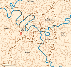
 Location (in red) within Paris inner and outer suburbs | |
| Coordinates: 48°48′00″N 2°10′01″E / 48.8°N 2.167°E | |
| Country | France |
| Region | Île-de-France |
| Department | Yvelines |
| Arrondissement | Versailles |
| Canton | Versailles-2 |
| Intercommunality | CA Versailles Grand Parc |
| Government | |
| • Mayor (2020–2026) | Olivier Lebrun[1] |
Area 1 | 3.49 km2 (1.35 sq mi) |
| Population (2022)[2] | 16,943 |
| • Density | 4,900/km2 (13,000/sq mi) |
| Time zone | UTC+01:00 (CET) |
| • Summer (DST) | UTC+02:00 (CEST) |
| INSEE/Postal code | 78686 /78220 |
| Elevation | 92–176 m (302–577 ft) |
| 1 French Land Register data, which excludes lakes, ponds, glaciers > 1 km2 (0.386 sq mi or 247 acres) and river estuaries. | |
Viroflay (French pronunciation: [viʁɔflɛ] ⓘ) is a commune in the Yvelines department in the Île-de-France in north-central France. It is located in the south-western suburbs of Paris 14.1 km (8.8 mi) from the center and 3 km (1.9 mi) from the Palace of Versailles.
The town motto is Lux mea lex which is Latin for "Light is my law".
History
[edit]This section is empty. You can help by adding to it. (January 2021) |
Population
[edit]Graphs are unavailable due to technical issues. Updates on reimplementing the Graph extension, which will be known as the Chart extension, can be found on Phabricator and on MediaWiki.org. |
| Year | Pop. | ±% p.a. |
|---|---|---|
| 1968 | 16,352 | — |
| 1975 | 15,696 | −0.58% |
| 1982 | 14,074 | −1.55% |
| 1990 | 14,689 | +0.54% |
| 1999 | 15,211 | +0.39% |
| 2007 | 16,000 | +0.63% |
| 2012 | 15,678 | −0.41% |
| 2017 | 16,129 | +0.57% |
| Source: INSEE[3] | ||
Gastronomy
[edit]The "Viroflay Omelette" is an omelette stuffed with spinach, ham and gruyère cheese.
The "Monstruous" is a variety of spinach, specific to Viroflay where it used to be cultivated.
Transport
[edit]Viroflay is served by Viroflay-Rive-Gauche station, which is an interchange station on Paris RER line C and on the Transilien Paris-Montparnasse suburban rail line.
It is also served by Viroflay-Rive-Droite station on the Transilien Paris-Saint-Lazare suburban rail line and by Chaville–Vélizy station on Paris RER line C.
See also
[edit]References
[edit]- ^ "Répertoire national des élus: les maires". data.gouv.fr, Plateforme ouverte des données publiques françaises (in French). 2 December 2020.
- ^ "Populations de référence 2022" (in French). The National Institute of Statistics and Economic Studies. 19 December 2024.
- ^ Population en historique depuis 1968, INSEE
External links
[edit]


