
Walsall Canal
| Walsall Canal | |
|---|---|
 Site of a removed bridge on the canal | |
 | |
| Specifications | |
| Length | 7 miles (11 km) |
| Locks | 8 |
| Status | Navigable |
| History | |
| Date of act | 1784 |
| Geography | |
| Connects to | Wyrley and Essington Canal Wednesbury Old Canal |
The Walsall Canal is a narrow (7 feet or 2.1 metres) canal, seven miles (11 km) long, forming part of the Birmingham Canal Navigations, and passing around the western side of Walsall, West Midlands, England.
Route
[edit]Walsall Canal | |||||||||||||||||||||||||||||||||||||||||||||||||||||||||||||||||||||||||||||||||||||||||||||||||||||||||||||||||||||||||||||||||||||||||||||||||||||||||||||||||||||||||||||||||||||||||||||||||||||||||||
|---|---|---|---|---|---|---|---|---|---|---|---|---|---|---|---|---|---|---|---|---|---|---|---|---|---|---|---|---|---|---|---|---|---|---|---|---|---|---|---|---|---|---|---|---|---|---|---|---|---|---|---|---|---|---|---|---|---|---|---|---|---|---|---|---|---|---|---|---|---|---|---|---|---|---|---|---|---|---|---|---|---|---|---|---|---|---|---|---|---|---|---|---|---|---|---|---|---|---|---|---|---|---|---|---|---|---|---|---|---|---|---|---|---|---|---|---|---|---|---|---|---|---|---|---|---|---|---|---|---|---|---|---|---|---|---|---|---|---|---|---|---|---|---|---|---|---|---|---|---|---|---|---|---|---|---|---|---|---|---|---|---|---|---|---|---|---|---|---|---|---|---|---|---|---|---|---|---|---|---|---|---|---|---|---|---|---|---|---|---|---|---|---|---|---|---|---|---|---|---|---|---|---|---|
| |||||||||||||||||||||||||||||||||||||||||||||||||||||||||||||||||||||||||||||||||||||||||||||||||||||||||||||||||||||||||||||||||||||||||||||||||||||||||||||||||||||||||||||||||||||||||||||||||||||||||||
At its southern end, the Walsall Canal is accessible from Pudding Green Junction on the Birmingham Canal Navigations (BCN) main line via a short section of the Wednesbury Old Canal, which runs for 0.7 miles (1.1 km) to Riders Green Junction. The Wednesbury Old Canal continues for another 0.5 miles (0.8 km) to a junction with the former Ridgeacre Branch Canal, after which it has been abandoned. From Riders Green Junction the canal immediately starts to descend through the Rider's Green flight of eight locks, which lower the canal by 45 feet (14 m). The B4149 Phoenix Street crosses just below the first lock, and Great Bridge Street crosses below the seventh. The towpath is on the west bank of the canal. The canal passes beneath two further bridges, carrying Brickhouse Lane South and the A461 Great Western Way and over an aqueduct crossing the River Tame to reach the final lock of the flight.[1][2] The canal is now at the 408-foot (124 m) Walsall Level.[3]
The former South Staffordshire line railway crosses, and there used to be a junction with the Toll End Communication Canal which rose through seven locks to the BCN Main Line. From Doe Bank Junction the Tame Valley Canal heads eastwards[4] and the very short Ocker Hill Tunnel Branch, now private moorings, fed water to the Ocker Hill pumps to replenish the Wednesbury Oak Loop and hence the Wolverhampton Level.[5] It continues northwards, where it is crossed by the A4037 Leabrook Road Bridge. Just before it reaches the junction with the unnavigable Gospel Oak Branch, the towpath crosses to the east bank at Wiggins Mill Bridge. The West Midlands Metro line crosses next, and it passes the stub of the Bradley Branch at Moorcroft Junction.[6] Holyhead Road Bridge and Darlaston Road Bridge are part of a roundabout, where the A41 and A4038 meet. The canal continues along the western edge of Darlaston, passing under Wolverhampton Street bridge and Midland Road Bridge, which carries the A462.[7]
In this area it passes the site of huge iron gates of the Patent Shaft factory (these gates have now been resited to a traffic island by the bus station in Wednesbury).[citation needed]
As it passes under Bughole Bridge which carries Willenhall Road and Bentley Road Bridge, the canal turns to the east. An aqueduct carries it over the Grand Junction Railway, to the north-east of Darlaston, and it reaches the junction with the former Anson Branch,[8] which once led to the Bentley Canal, abandoned in 1961.[4] Another aqueduct carries it over Bentley Mill Way and the River Tame, before it reaches the M6 motorway bridge, just south of junction 10. The A4148 crosses at Pagetts Bridge as it turns to the north and there are bridges at Rollingmill Street and Bridgeman Street, where the towpath crosses to the west bank, but continues on the east bank along the Walsall Town Arm. This turns off at Walsall Junction, heading to the east into Walsall, and the main canal continues northwards, ascending 65 feet (20 m) through the Walsall Locks flight, numbered from 1 to 8 from the top downwards. The A454 Wolverhampton Road crosses between locks eight and seven, Birchills Street Bridge crosses between locks five and four, and Birchills Bridge crosses between locks two and one. An aqueduct crosses a dismantled railway line, part of the Wolverhampton and Walsall Railway, and Stephenson Avenue passes over the canal before it reaches Birchills Junction on the Wyrley & Essington Canal.[9]
The canal starts at the Birmingham Level, descends 45 feet (14 m) to the Walsall Level, then rises 65 feet (20 m) to the Wolverhampton Level.
History
[edit]The Walsall Canal has a complex early history. When the Birmingham and Fazeley Canal was first promoted, it was intended to link the mineral resources of Wednesbury to the Coventry Canal and the Oxford Canal. A network of small canals in the Wednesbury area would serve the coal and ironstone mines, which were at a lower level than the Birmingham Canal, later the Birmingham Canal Navigations. The new canal was a competitor to the Birmingham Canal. It was supported by the Earl of Dudley, whose property near Broadwaters would benefit from its construction, and opposed by the Earl of Dartmouth, as the canal would cross his land. The Birmingham Canal proposed an alternative, involving branches from the Wednesbury Canal, a little further to the south.[10]
The two companies had reached a compromise by the time a bill was submitted to Parliament. When the Birmingham and Fazeley Canal Act 1783 (23 Geo. 3. c. 92) was passed, it authorised the new company to build a canal between Fazeley and Aston, where it rose through a flight of locks to meet the Birmingham Canal at its eastern end. They could then use the BCN main line and the Wednesbury Canal to reach Ryder's Green, where they would build a detached part of their canal to reach Broadwaters and the mines in that area. The two companies amalgamated in 1784, becoming the Birmingham Canal Navigations in 1794. John Smeaton was employed to be the engineer for both sections of the new canal, and John Pinkerton, a well-known canal contractor, was engaged to build the canal from Ryder's Green to Broadwaters, and then some of the main line from Fazeley Junction. This was the first section of what was to become the Walsall Canal.[11] The 1783 act also authorised six collateral cuts from the Broadwaters Canal, including the Toll End and Gospel Oak branches.[12]
At the time, Broadwaters was a series of pools surrounded by marshy ground. Eight locks were needed to reach the lower level of 406 feet (124 m) above ordnance datum, where the mines were located. Pinkerton's men built an aqueduct of brick and stone across the River Tame, to reach Great Bridge, Toll End and Leabrook. To supply the canal with water, they constructed a pumping engine, which had the added benefit that it drained the swampy ground, to enable it to be used for industry subsequently. The network of small canals would be built as new mines and iron works were developed. They included the Danks Branch, the Gospel Oak Branch, the Ocker Hill Tunnel Branch and the Toll End Branch. The Ocker Hill Tunnel was 5 feet (1.5 m) in diameter, lined with brick, which carried water to shafts where a steam pumping engine raised it to provide an extra water supply to the Birmingham Canal's 473-foot (144 m) Wolverhampton Level. Pinkerton completed the Broadwaters contract successfully.[13]
Meanwhile the Birchills Branch of the Wyrley and Essington Canal reached Bloxwich Wharf to the north-west of Walsall by 1798.[14] Much of this branch from Sneyd Junction was later subsumed into the new mainline of the Wyrley and Essington, when the canal was extended from Birchills Junction to Huddlesford Junction on the Birmingham and Fazeley Canal, authorised by the Wyrley and Essington Canal Act 1794 (34 Geo. 3. c. 25). The final 700 metres (2,300 ft) of the Birchills Branch towards Walsall was left as a stub, but was little used. By 1809, a writer reported that it was dammed off and had been drained for some years, after it broke through into Birchill Colliery Works.[15]
What was by then known as the Birmingham and Birmingham and Fazeley Canal Company, soon to be incorporated as the Birmingham Canal Navigations Company, was authorised by the combined company's sixth Act of Parliament, the Birmingham Canal Navigation Act 1794 (34 Geo. 3. c. 87), of 17 April 1794 to extend the canal from Broadwaters to Walsall. It allowed the Company to borrow £45,000, with which to construct the canal to Walsall and three branches to serve iron-stone and coal mines in the locality, all to be completed within three years.[16] Construction began at Broadwaters and reached Darlaston by May 1798. The contractors were Jacob Twigg and Joseph Smith, and the work included a deep cutting to the north of Broadwaters. The whole area has subsequently been affected by subsidence from coal mining, and the scale of their task is now difficult to visualise.[17] Twigg and Smith were engaged to complete the second phase of construction in April 1798, and had until 1 January 1799 to complete excavation of the channel to Walsall. They completed it in 1799, but the canal remained unfinished in 1800.[18] The canal was mapped by John Snape (1737–1816) in 1808 and this was to be his last known map.[19]
The small gap between the Birmingham Canal Navigations line to Walsall and the Wyrley and Essington Canal's Birchills Branch was of concern to businessmen to the north of Walsall, whose access to the south was by a very circuitous route. An independent canal to link the two was planned, but in 1839 the BCN agreed to build a connection. Thomas Townshend was engaged as the contractor for the Walsall Junction Canal in July 1840. It required eight locks to raise the canal by 65 feet (20 m) from the Walsall Level to the Wolverhampton Level of the Wyrley and Essington Canal.[20] The link, which included refurbishment of the final 0.5 miles (0.8 km) of the Birchills Branch from Birchills Junction, was finished in March 1841, and this fourth phase of construction completed the through route and what is now known as the Walsall Canal.[21][22]
Branches
[edit]The canal had a number of branches and connections. The most southerly was the Haines Branch, which was 0.6 miles (1.0 km) long,[3] and left the canal just below Ryders Green bottom lock. It passed under the Great Bridge Branch railway, Great Bridge Street, which carried a road with a street tramway, and Sheepwash Lane, where the towpath crossed from the east bank to the west. Immediately after the bridge, an aqueduct carried the canal over the River Tame, and a basin to the east served Canal Brick Works. A basin to the west served Denbign Hall Colliery, which was disused by 1904, and the branch ended at wharves for Pumphouse Brick Works. The colliery is now the site of the residential area of Horseley Heath, and much of Pumphouse Brick Works is a lake.[23][24]
Just to the north of the South Stafordshire line railway bridge, the Danks Branch turned off to the east. It was 0.5 miles (0.8 km) long and was crossed by the railway line twice. In 1904 it ended at Danks Branch Wharf, on the south bank of the Tame Valley Canal. The towpath ran along the east bank.[23] At Toll End Junction, the Toll End Branch headed west. It was one of the six collateral cuts authorised by the Birmingham and Fazeley act of 1783.[12] Work began in March 1800, with Jacob Twigg as contractor.[25]
To the north, a basin served the Crown Brick Works, near Ocker Hill, and the Lower Ocker Hill Branch delivered water to Ocker Hill Tunnel, from where it was pumped to the Ocker Hill Branch. It reached the BCN Main Line by joining the Wednesbury Oak Loop at Summer Hill.[23]
The canal was joined by the Tame Valley Canal, which was built in the 1840s to provide a northern bypass for the overloaded Farmers Bridge Locks, at the eastern end of the BCN Main Line. The original Act of Parliament, the Birmingham Canal Navigations Act 1839 (2 & 3 Vict. c. lxi) authorised a canal from Salford to join the Danks Branch, but was altered by the Wyrley and Essington Canal Navigation Act 1840 (3 & 4 Vict. c. xxiv), which changed the route. The canal opened on 14 February 1844.[26]
Points of interest
[edit]| Point | Coordinates (Links to map resources) |
OS Grid Ref | Notes |
|---|---|---|---|
| Ryders Green Junction | 52°31′22″N 2°01′20″W / 52.5228°N 2.0221°W | SO985916 | Wednesbury Old Canal |
| Toll End Junction | 52°32′14″N 2°02′08″W / 52.5372°N 2.0356°W | SO976932 | Toll End Communication Canal |
| Ocker Hill Tunnel Branch | 52°32′22″N 2°02′09″W / 52.5394°N 2.0357°W | SO976934 | |
| Tame Valley Junction (Doe Bank Junction) | 52°32′24″N 2°02′07″W / 52.5400°N 2.0354°W | SO976935 | Tame Valley Canal |
| Gospel Oak Branch Junction | 52°32′57″N 2°02′13″W / 52.5493°N 2.0370°W | SO975945 | |
| Moorcroft Junction | 52°33′15″N 2°02′28″W / 52.5541°N 2.0411°W | SO972951 | Bradley Branch |
| Anson Branch Junction | 52°34′39″N 2°01′20″W / 52.5775°N 2.0221°W | SO986977 | Anson Branch, leading to Bentley Canal |
| Walsall Junction | 52°35′05″N 1°59′34″W / 52.5848°N 1.9928°W | SP005986 | Short branch to Walsall centre |
| Birchills Junction | 52°35′55″N 1°59′52″W / 52.5987°N 1.9979°W | SK002000 | Wyrley and Essington Canal |
Gallery
[edit]From north to south:
-
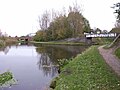 Birchills Junction
 -
 Walsall Locks toll office and Boaters Mission
 -
 Circular weir at Walsall Lock No 5
 -
 Walsall Junction - the Town Branch
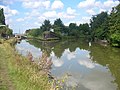
 -
 Walsall Canal by Spine Road
 -
 Gospel Oak Junction (Walsall canal runs left and right)
 -
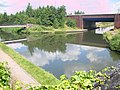 Tame Valley Junction - start of the Tame Valley Canal
 -
 Ocker Hill Tunnel Branch Junction (now private)
 -
 Ryders Green Junction - southern terminus


See also
[edit]References
[edit]- ^ Nicholson 2006, p. 39.
- ^ Ordnance Survey, 1:2500 map
- ^ a b Cumberlidge 2009, p. 77.
- ^ a b Cumberlidge 2009, p. 76.
- ^ Nicholson 2006, p. 52.
- ^ Nicholson 2006, pp. 52, 54–55.
- ^ Nicholson 2006, pp. 47, 54.
- ^ Nicholson 2006, pp. 47, 50.
- ^ Nicholson 2006, p. 50.
- ^ Shill 2005, pp. 32–33.
- ^ Shill 2005, p. 33.
- ^ a b Broadbridge 1974, pp. 40–41.
- ^ Shill 2005, pp. 33–34.
- ^ Paget-Tomlinson 1993, p. 217.
- ^ Hadfield 1985, p. 96.
- ^ Priestley 1831, pp. 72–73.
- ^ Shill 2005, p. 44.
- ^ Shill 2005, pp. 44–45.
- ^ Skempton 2002, p. 640.
- ^ Shill 2005, p. 98.
- ^ Broadbridge 1974, p. 73.
- ^ Cumberlidge 2009, p. 79.
- ^ a b c Ordnance Survey, 25-inch map, 1904
- ^ Ordnance Survey, 1:25000 map
- ^ Shill 2005, p. 45.
- ^ Handfield 1985, p. 89.
Bibliography
[edit]- Broadbridge, S. R. (1974). The Birmingham Canal Navigations, Vol. 1 1768 - 1846. David & Charles. ISBN 978-0-7509-2077-3.
- Cumberlidge, Jane (2009). Inland Waterways of Great Britain (8th Ed.). Imray Laurie Norie and Wilson. ISBN 978-1-84623-010-3.
- Hadfield, Charles (1985). The Canals of the West Midlands. David and Charles. ISBN 978-0-7153-8644-6.
- Nicholson (2006). Nicholson Guides Vol 2: Severn Avon and Birmingham. Harper Collins. ISBN 978-0-00-721110-4.
- Paget-Tomlinson, Edward (1993). The Illustrated History of Canal & River Navigations. Sheffield Academic Press. ISBN 978-1-85075-277-6.
- Pearson, Michael (1989). Canal Companion - Birmingham Canal Navigations. J. M. Pearson & Associates. ISBN 978-0-907864-49-3.
- Priestley, Joseph (1831). "Historical Account of the Navigable Rivers, Canals and Railways of Great Britain". Archived from the original on 3 March 2016.
- Shill, Ray (2005). Birmingham and the Black Country's Canalside Industries. Tempus Publishing. ISBN 978-0-7524-3262-5.
- Skempton, Sir Alec; et al. (2002). A Biographical Dictionary of Civil Engineers in Great Britain and Ireland: Vol 1: 1500 to 1830. Thomas Telford. ISBN 978-0-7277-2939-2.