
Woodhead railway station
This article includes a list of general references, but it lacks sufficient corresponding inline citations. (November 2024) |
Woodhead | |
|---|---|
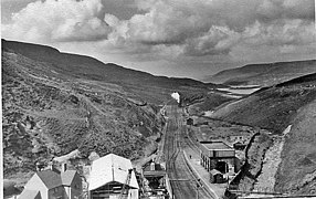
 Second Woodhead station seen from above tunnel in 1979 | |
| General information | |
| Location | Woodhead, High Peak England |
| Coordinates | 53°29′43″N 1°49′53″W / 53.4954°N 1.8314°W |
| Platforms | 2 |
| Other information | |
| Status | Disused |
| History | |
| Original company | Sheffield, Ashton-under-Lyne and Manchester Railway |
| Pre-grouping | Great Central Railway |
| Post-grouping | London and North Eastern Railway |
| Key dates | |
| 8 April 1844 | Opened |
| 1953 | Moved to new alignment |
| 27 July 1964 | Closed |
Woodhead railway station served the hamlet of Woodhead, in Derbyshire, England; it was a stop on the now-disused Woodhead Line between Manchester and Sheffield.
History
[edit]The station was opened on 8 April 1844 by the Sheffield, Ashton-under-Lyne and Manchester Railway. [1] It was served by stopping passenger trains operating on the route between Manchester London Road and Sheffield Victoria.
It was later operated by the Great Central Railway and the London and North Eastern Railway.
A new station was opened in 1953 by the Eastern Region of British Railways on a different site, in conjunction with the opening of the new Woodhead Tunnel and electrification of the line.
It was closed on 27 July 1964, but the line remained open for passengers trains until 1970 and to freight traffic until 1981.[1]
| Preceding station | Disused railways | Following station | ||
|---|---|---|---|---|
| Crowden | SAMR Woodhead Line |
Dunford Bridge |
The site today
[edit]Both platforms of the second station are extant; they are accessible on the Longdendale Trail shared-use path, which occupies the former trackbed between Hadfield and the west portal of the Woodhead Tunnel.[1]
Gallery
[edit]-
 The original Woodhead station seen from above Woodhead tunnel in 1951
 -
 The remains of the station in 2005
 -
 Disused platform in 2012


.jpg)
References
[edit]- ^ a b c Catford, Nick (26 May 2017). "Station name: Woodhead". Disused Stations. Retrieved 14 March 2025.
External links
[edit]
This article on a railway station in the East Midlands is a stub. You can help Wikipedia by expanding it. |