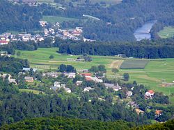
Zgornja Dobrava, Radovljica
Appearance
Zgornja Dobrava | |
|---|---|
 | |
| Coordinates: 46°18′34.91″N 14°12′48.03″E / 46.3096972°N 14.2133417°E | |
| Country | |
| Region | Upper Carniola |
| Statistical region | Upper Carniola |
| Municipality | Radovljica |
| Elevation | 508.8 m (1,669.3 ft) |
| Population (2002) | |
| • Total | 128 |
| [1] | |
Zgornja Dobrava (pronounced [ˈzɡoːɾnja dɔˈbɾaːʋa]) is a settlement in the Municipality of Radovljica in the Upper Carniola region of Slovenia.
Name
[edit]Zgornja Dobrava was attested in written sources as Oberhard in 1351 and Hard in 1368.[2] The name Zgornja Dobrava literally means 'upper Dobrava' and reflects its elevation contrast with neighboring Srednja Dobrava (literally, 'middle Dobrava', about 11 meters or 36 feet lower) and Spodnja Dobrava (literally, 'lower Dobrava', about 28 meters or 92 feet lower). The place name Dobrava is relatively frequent in Slovenia. It is derived from the Slovene common noun dobrava 'gently rolling partially wooded land' (and archaically 'woods, grove'). The name therefore refers to the local geography.[3]
References
[edit]- ^ Statistical Office of the Republic of Slovenia Archived November 18, 2008, at the Wayback Machine
- ^ "Zgornja Dobrava". Slovenska historična topografija. ZRC SAZU Zgodovinski inštitut Milka Kosa. Retrieved September 25, 2022.
- ^ Snoj, Marko (2009). Etimološki slovar slovenskih zemljepisnih imen. Ljubljana: Modrijan. p. 111.
External links
[edit] Media related to Zgornja Dobrava at Wikimedia Commons
- Zgornja Dobrava on Geopedia


