Hondschoote
Hondschoote
Hondschote | |
|---|---|
 Hondschoote | |
| Coordinates: 50°58′49″N 2°35′10″E / 50.9803°N 2.5861°E | |
| Country | France |
| Region | Hauts-de-France |
| Department | Nord |
| Arrondissement | Dunkirk |
| Canton | Wormhout |
| Intercommunality | CC Hauts de Flandre |
| Government | |
| • Mayor (2020–2026) | Hervé Saison[1] |
Area 1 | 23.66 km2 (9.14 sq mi) |
| Population (2022)[2] | 4,010 |
| • Density | 170/km2 (440/sq mi) |
| Time zone | UTC+01:00 (CET) |
| • Summer (DST) | UTC+02:00 (CEST) |
| INSEE/Postal code | 59309 /59122 |
| Elevation | 0–19 m (0–62 ft) (avg. 5 m or 16 ft) |
| 1 French Land Register data, which excludes lakes, ponds, glaciers > 1 km2 (0.386 sq mi or 247 acres) and river estuaries. | |
Hondschoote (French pronunciation: [ɔ̃(t)skɔt];[3][4] from Dutch; Hondschote in the modern Dutch spelling) is a commune of the Nord département, in northern France.[5]
Geography
[edit]Hondschoote borders Flanders, the Dutch-speaking part of Belgium. It lies 12 km from the North Sea coast.
Population
[edit]| Year | Pop. | ±% p.a. |
|---|---|---|
| 1968 | 2,722 | — |
| 1975 | 2,964 | +1.22% |
| 1982 | 3,716 | +3.28% |
| 1990 | 3,654 | −0.21% |
| 1999 | 3,815 | +0.48% |
| 2007 | 3,879 | +0.21% |
| 2012 | 4,072 | +0.98% |
| 2017 | 4,083 | +0.05% |
| Source: INSEE[6] | ||
Sights
[edit]Hondschoote used to have several windmills, but only the Noordmeulen and the Spinnewyn survive. The church dates from the 14th century. Its tower was completed in 1513, burned during religious troubles in 1582 and restored in the early 17th century. The church is a surprisingly large building for this small town. On the square are several fine old buildings, particularly the town hall. The tourist office is a tiny structure near the front of the church.
History
[edit]Before 1659, Hondschoote was part of the Spanish Netherlands. A thriving wealthy cloth-town, it had thousands of small workshops making serge cloth from locally grown flax. Events such as Beeldenstorm, conquest by France and the War of the Spanish Succession, however, brought an end to prosperity. The cloth-makers fled to what is now Belgium and England, taking their skills to benefit France's rivals.
The battle of Hondschoote in 1793 was a key event in saving the French First Republic from an invasion by English, Hanoverian and Austrian troops that had been sent in order to rid France of revolutionaries. During the battle, windmill Spinnewyn served as look-out post and first-aid station.


Heraldry
[edit] |
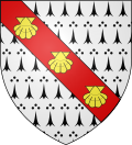
The arms of Hondschoote are blazoned : Ermine, on a bend gules, 3 escallops bendwise Or. (Ghyvelde and Hondschoote use the same arms.)
|
Twin towns
[edit]See also
[edit]References
[edit]- ^ "Répertoire national des élus: les maires". data.gouv.fr, Plateforme ouverte des données publiques françaises (in French). 2 December 2020.
- ^ "Populations de référence 2022" (in French). The National Institute of Statistics and Economic Studies. 19 December 2024.
- ^ "Hondschoote : jusqu'à 80 euros de chèque carburant pour les travailleurs en difficulté - YouTube". www.youtube.com. Retrieved 4 February 2021.
- ^ "La quincaillerie d Hondschoote 59 cherche repreneur - YouTube". www.youtube.com. Retrieved 4 February 2021.
- ^ INSEE commune file
- ^ Population en historique depuis 1968, INSEE


